
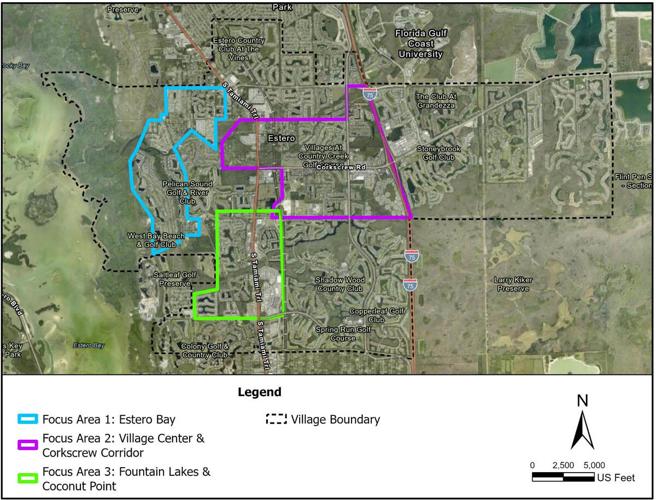

A map from the Village of Estero's 2026 Adaptation Plan identifies three areas targeted for flood-resilience planning: the Estero Bay waterfront, the village center and Corkscrew Road corridor, and the Fountain Lakes-Coconut Point area. The assessment considers storm surge, heavy rainfall and future sea level rise.
Village of Estero would have low to moderate flooding risks from a 100-year storm, but flooding will worsen as sea levels rise during the rest of the century.
“Tidal flooding is not of major concern, but rare, extreme storm events and heavy rainfall present a greater threat,” according to an assessment by APTIM Environmental & Infrastructure in its 147-page report. The village used a $450,000 grant from Lee County to pay for the study.
Village Council received highlights from the assessment during its Oct. 28 meeting.
A 100-year event has a 1% chance of occurring in any given year.
“There’s things that we can improve on, but overall, we’re in good shape compared to most areas throughout Florida,” said David Willems, Estero’s public works director. “One of the reasons we did this report was that it allows us additional funding sources through the state. You have to have a vulnerability assessment in order to get certain grants through the state.”
The assessment found that 17% of roads — most west of Broadway — would be impacted by up to 9 feet of water. The farther inland you go, the less flooding there would be, Willems said. Two bridges would flood — the U.S. 41 bridge over the Estero River and the Sandy Lane bridge, farther east — with 1 foot of water covering the roads.
The study found that 10% of lift stations would flood with up to 6 feet of water, 11% of communication facilities with up to 1 foot of water and 6% of bus stops with up to 2 feet of water.
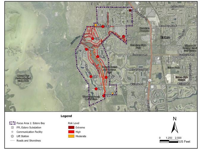
The study looked at three areas that are at higher risk than others in the village. The most vulnerable are along Estero Bay, where West Bay Club and Estero River Heights are located. They were hit hard by storm surge flooding from Hurricane Ian. Village and private roads, lift stations, mobile home parks, a cell tower, an FPL substation and homes along the shoreline are vulnerable.

A map from Estero's 2026 Adaptation Plan highlights vulnerable infrastructure along Estero Bay and the lower Estero River, including roads, wastewater lift stations, communication facilities and the FPL Estero substation. The area includes West Bay Club and communities affected by Hurricane Ian's storm surge.
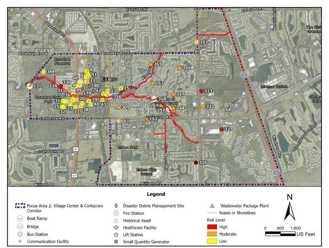
The second area is along the Estero River and the central core of the village. The area is vulnerable to storm surge and rainfall. Historical assets, such as the Koreshan buildings, the boat ramp at Koreshan State Park, private healthcare facilities, bus stations and two bridges would be vulnerable.

A map identifies vulnerable infrastructure along the Estero River and the village center, including bridges, bus stops, wastewater facilities and historic resources near Koreshan State Park. Estero's adaptation plan recommends drainage improvements and protections for critical infrastructure in the corridor.
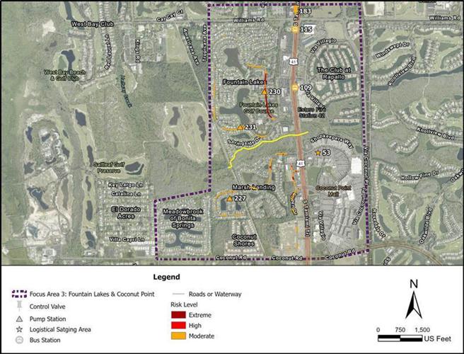
The third area, mostly residential, includes Fountain Lakes, Marsh Landing and Coconut Point Mall. The area is susceptible to flooding and wildfires, the report said. Roads in Fountain Lakes, bus stops, lift stations and Coconut Point Mall, which could serve as a staging area, would be most vulnerable.

A map from the Village of Estero's 2026 Adaptation Plan identifies vulnerable infrastructure in the Fountain Lakes and Coconut Point area. The report cites localized rainfall flooding, drainage limitations and potential disruptions to transit stops, utilities and commercial facilities.
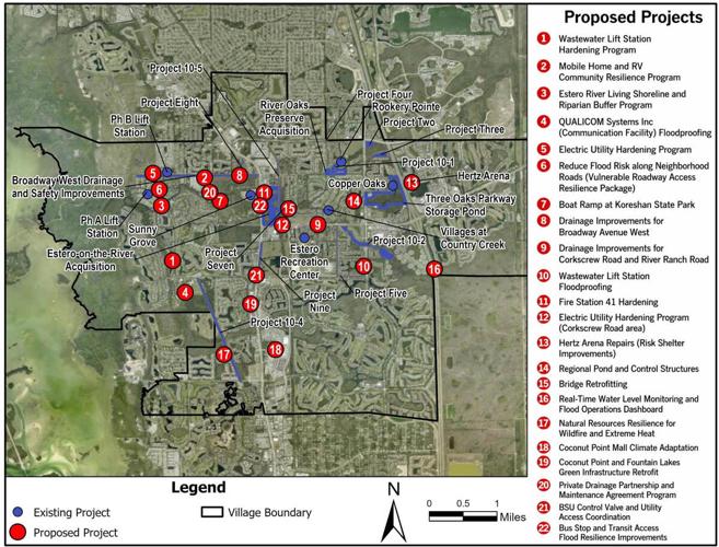
The analysis recommended 22 projects, ranging from hardening wastewater lift stations and mobile home and recreational vehicle resilience programs to shoreline improvements along the Estero River, floodproofing communications facilities and floodproofing Fire Station 41.

A map from Estero's 2026 Adaptation Plan identifies existing and proposed flood-resilience projects throughout the village. Recommendations include drainage improvements, wastewater lift station protections, regional stormwater storage and upgrades to vulnerable roads and bridges.
Drainage improvements for Broadway Avenue West top the list, followed by improving wastewater lift stations, building regional ponds and control structures, and fixing flooding problems at Fountain Lakes.
“What we’ll be doing going forward when we start talking about next year’s CIP (capital improvements plan) is looking at this list, adding them to our CIP and then figuring out which ones we do first,” Willems said.
Willems didn’t discuss the report’s 2050 and 2080 scenarios, which account for sea level rise.
Under these future storm surge scenarios, much of Estero west of U.S. 41 would be impacted.
On the east side, Estero Country Club at The Vines, as well as most of the area bounded by Broadway Avenue West to the north and Corkscrew Road to the south — including the Villages at Country Creek — would be flooded, the report said.
The area bounded by U.S. 41 to the west, Estero Parkway to the north, Broadway Avenue East to the south and Seminole Gulf Railway to the east also would be inundated.
Under the 2050 storm surge scenario, multiple village-owned assets would be vulnerable, but critical infrastructure, such as drinking water and transmission lines, would be safe.
Under the 2080 scenario, village-owned bridges over the Estero River would be flooded, with as much as 11 feet of water covering the roads. Six bus terminals along U.S. 41 would flood, with two locations experiencing up to 8 feet of water.
Village roadways would see significant flooding, ranging from 3 feet near Spring Creek Road to 18 feet near Sandy Lane.
Two railroad bridges would experience up to 18 feet of flooding, and more than one-third of the railroad tracks, which are scheduled to be turned into a bike trail, would have between 3 and 12 feet of water, the report said.
Communication facilities, which would have 1 foot of flooding today, would experience up to 6 feet in 2080, while the FPL Estero substation would have 9 feet of floodwater.
Corkscrew Road, which acts as a drainage divide, would prevent floodwaters from flowing south, the report said.
(0) comments
Welcome to the discussion.
Log In
Keep it Clean. Please avoid obscene, vulgar, lewd, racist or sexually-oriented language.
PLEASE TURN OFF YOUR CAPS LOCK.
Don't Threaten. Threats of harming another person will not be tolerated.
Be Truthful. Don't knowingly lie about anyone or anything.
Be Nice. No racism, sexism or any sort of -ism that is degrading to another person.
Be Proactive. Use the 'Report' link on each comment to let us know of abusive posts.
Share with Us. We'd love to hear eyewitness accounts, the history behind an article.